
Dictionary, Census of Population, 2021
Figure 1.2
Standard Geographical Classification (SGC) hierarchy

Release date: February 9, 2022
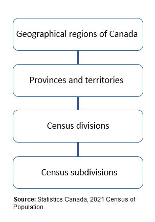
Description for Figure 1.2
Figure 1.2 is a graphical representation of the hierarchy of geographic areas that make up the Standard Geographical Classification (SGC). There are four boxes that are stacked vertically and linked together with lines. The boxes are labelled with the geographic areas that make up the SGC hierarchy. The bottom box is the census subdivisions (CSD) level, which is the lowest level in the SGC hierarchy. The CSD (bottom box) aggregates up to the census divisions (second box), which then aggregates up to the provinces and territories (third box), which then aggregates up to the highest level in the hierarchy, the geographical regions of Canada (top box).
Source: Statistics Canada, 2021 Census of Population.
- Date modified: