
Dictionary, Census of Population, 2016
Core, fringe and rural area
Definition
The terms 'core,' 'fringe' and 'rural area' distinguish between population centres (POPCTR) and rural areas (RA) within a census metropolitan area (CMA) or census agglomeration (CA).
A CMA or CA can have two types of cores: the core and the secondary core. The core is the population centre (POPCTR) with the highest population, around which a CMA or a CA is delineated. The boundaries and population counts of the population centres (core) used to delineate the CMAs or CAs are taken from the previous census. The core must have a population of at least 50,000 persons in the case of a CMA, or at least 10,000 persons in the case of a CA.
The secondary core is a population centre with at least 10,000 persons (based on the previous census) and that is within a CMA or CA, but outside the main municipality (census subdivision) that contains the core. The secondary core can also be the core of a CA that has been merged with an adjacent CMA.
The term 'fringe' is applied to all population centres (POPCTRs) within a CMA or CA that have less than 10,000 persons (based on the previous census) that are not contiguous to a core or a secondary core. In some circumstances (POPCTRs) that have 10,000 or more persons (based on the previous census) are designated 'fringe'. These are POPCTRs that exist inside census subdivisions (CSD) that are already contiguous with a core or a secondary core. All territory within a CMA or CA that is not classified as a core or fringe is classified as 'rural area'.
Reported in
2016, 2011
Remarks
While every CMA and CA has a core, it may or may not have a secondary core, a fringe or a rural area. See Figure 1.12.
Figure 1.12
Example of a census metropolitan area or a census agglomeration, showing core, secondary core, fringe and rural area
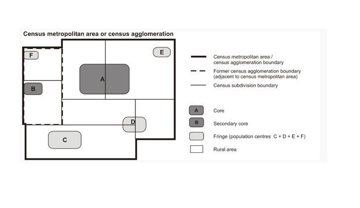
Description of Figure 1.12
Figure 1.12 is a graphical representation of a census metropolitan area (CMA) or census agglomeration (CA) and its component census subdivisions (CSDs), core, fringe, and rural area. A fictional grouping of seven CSDs, shown as white polygons, represents the CSDs that form a CMA. A thick black line outlines the perimeter of the CSDs to identify the boundary of the CMA. Within the CMA/CA limits, two adjacent polygons in the top left quadrant are bordered with a thick dashed line to represent a former CA boundary, which was adjacent to the CMA or CA before being merged into it.
Within the CMA/CA boundary are six shaded, smaller polygons that overlap the CSD polygons. The largest of these smaller polygons, labelled 'A' and shaded dark grey, represents the core of the CMA/CA and appears just above the centre of the CMA/CA polygon. A second small polygon, also shaded dark grey and labelled 'B', appears on the far left of the CMA/CA and represents the secondary core. Four other smaller polygons, shaded light grey and labelled C, D, E and F, are scattered within the CMA/CA. These light grey polygons represent fringe (population centres that are neither a core nor a secondary core). The remaining white area of the CSDs is referred to as rural area.
A legend appears to the right of the diagram that defines the symbols used in the figure to represent the CMA/CA, the former CA boundary, CSD boundaries, the core, secondary core, fringe and rural area.
Source: Statistics Canada, 2016 Census of Population.
Population counts for population centres are published according to the class of population centre, regardless of whether they are inside or outside of a CMA or CA. Population centres are classified into one of three groups, depending on the size of their population:
- small population centres, with a population between 1,000 and 29,999
- medium population centres, with a population between 30,000 and 99,999
- large urban population centres, with a population of 100,000 or more.
Refer to related definitions of census metropolitan area (CMA) and census agglomeration (CA); population centre (POPCTR) and rural area (RA).
Changes prior to the current census
For the 2011 Census, the terms 'core,' 'fringe' and 'rural area' replace the terms 'urban core,' 'urban fringe' and 'rural fringe.' These terms distinguish between population centres (POPCTRs) and rural areas (RAs) within a census metropolitan area (CMA) or census agglomeration (CA).
Prior to 2011, the terms 'urban core,' 'secondary urban core,' 'urban fringe' and 'rural fringe' were used.
Beginning in 2001, the concept of the secondary urban core was used to describe the urban core of a CA that merged with an adjacent CMA.
Beginning in 1996, the term 'urban core' replaced the term 'urbanized core.' The term 'urbanized core' was used from 1971 to 1991.
Prior to 1996, this concept was known as CMA/CA parts.
Beginning in 1986, primary CMAs (PCMAs) and primary CAs (PCAs) were delineated within some CMAs and CAs. Because of this change, some urban areas that were urban fringes of 1981 CMAs or CAs became urban cores of 1986 PCMAs or PCAs.
For 1976 and 1971, the urbanized core was further broken down into the 'largest city' and 'remainder.'
For 1966 and 1961, the urban part of the CMA was divided into the 'metropolitan area – urban' (continuous built-up area) and the 'metropolitan area – outside urban' (non-continuous built-up area); the remaining rural part was known as 'metropolitan area – rural.'
- Date modified: